Our Delivery Manager Tom Guilbert describes the improvements to the Hydrology Service we’ve released today for the Environment Agency.
Introduction
In previous blogs I’ve described the hugely expanded version of the Hydrology Service and its underpinning API that we built and run for the Environment Agency (EA). The service is built on our Agora Measurement Store technology. It is one of the largest open hydrological datasets in the world, with over four billion readings covering rainfall, river flow, river level, groundwater level and water quality time series.
In response to feedback and to open up even more of their monitoring archive EA asked us to develop some enhancements to the service, which go live today.
Closed Stations
The version of the Hydrology Service released at the end of March 2023 included the EA’s water quality continuous monitoring archive. The data stretches back 16 years and, because the stations often only operate for a few months, the archive is mostly made up of historical data from these closed stations. The Hydrology Service can be used to find and interrogate water quality data from closed stations, with date filters and special markers on the user interface.
The main enhancement released today is to support another huge increase in data by allowing the EA to publish time series from the other closed stations in their hydrometric archive – covering rainfall, river flows and level, and groundwater levels. Most of this data covers the period from 1965 to 2010.
This archived data is not available publicly at the moment, and to add it to the Hydrology Service we needed to ensure that we could support up to 20,000 new stations. Data will be added over the next 18 months as and when it has been reviewed by EA. Some of the changes the service needed were:
- Automation to allow EA to add stations and time series without our support, and to close open stations (and vice versa)
- New closed station icons for the Hydrology Data Explorer
- Performance enhancements to the map view to handle adding up to 20,000 more stations
Other Enhancements
Based on user feedback, the EA has identified some other critical improvements to the service we’ve implemented as part of this project. These include:
- Being able to differentiate all of the different station types more clearly on the map (see screenshot)
- Adding a new type of station to differentiate groundwater stations with automated continuous monitoring (logged) and those where only manual (dipped) measurement occurs on a less frequent basis
- Enhancements to integrate the map filter controls with search, so that your search results only contain the station types on the map
- Adding data quality flags to rainfall bar charts (see screenshot)
- Other small improvements to the user experience
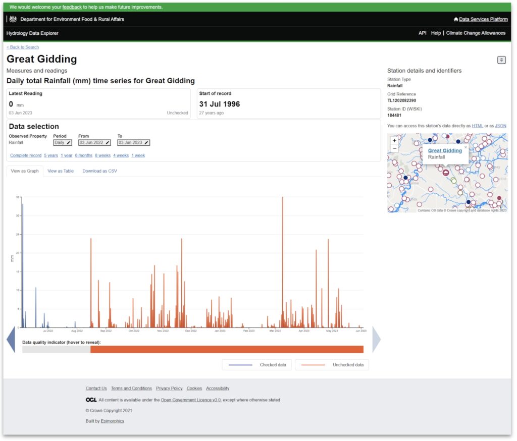
The screenshot above shows the new version of the Hydrology Data Explorer station page. This is a rainfall station page, which now includes data quality flags on and below the graph. Note also the new station marker colours on the map, including differentiating open stations from closed (with solid colour versus white).
Conclusion
Now we’ve released these enhancements, we’re working with the EA to support them with the process of adding new closed stations and all the underlying readings to the service over the next 18 months. This will add even more data to the open hydrological archive, made possible by our Agora Measurement Store technology and the hard work and expertise of the team here at Epimorphics.
Let us know if you use the service, either via the user interface of the API. We hope you like it!
You can also get in touch with the Environment Agency to give feedback via their dedicated survey or email the team who manage the service at hydrometricopendata@environment-agency.gov.uk